NASA's DRCS & LHASA utilized for US PNW weather hazards, Dec 2025
The Pacific Northwest of the United States has experienced incredibly heavy rainfall since early December 2025, due to atmospheric rivers. As the deluge continued, major rivers overflowed and resulted in flooding and mudslides, leading to washed-out roads and damage throughout communities. Thomas Stanley (617/UMBC), one of the LHASA software developers, shared with us the NASA Earth Observatory article, "Pacific Moisture Drenches the U.S. Northwest," in which Kathryn Hansen writes, "According to the National Weather Service, preliminary ground-based measurements showed that several locations in western Washington received more than 10 inches (250 mm) of rain over a 72-hour period ending on the morning of December 11."
In response to these conditions and potential future disasters, members of the NASA Disaster Response Coordination System worked with officials to provide timely maps and forecasts of possible landslides and additional flooding. By utilizing the Landslide Hazard Assessment for Situational Awareness (LHASA) model, decision makers can obtain near real-time information on which areas are in need of immediate preparation and response. The NASA Disasters - Washington Atmospheric Rivers 2025 webpage provides more information in addition to a link to the related Maps & Data on the NASA Disasters Portal. The portal includes images compiled from data from Sentinel-1, NOAA-20, GPM IMERG, Landslide Hazard Nowcast, and other sources to show fire events, flood detection, and landslide events; these images also are available on a Map Viewer.
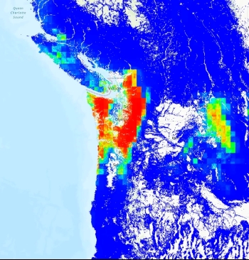 Image: This map shows forecasted landslide hazard likelihood in the Pacific Northwest for Dec. 10, 2025, based on NASA’s LHASA. Red areas indicate higher landslide risk, while blue areas indicate lower. Credit: NASA GSFC. (Obtained from NASA Disasters - Washington Atmospheric Rivers 2025 page (see above); also available at Landslide Hazard Nowcast and Exposure for the Washington Atmospheric River December 2025.)
In response to these conditions and potential future disasters, members of the NASA Disaster Response Coordination System worked with officials to provide timely maps and forecasts of possible landslides and additional flooding. By utilizing the Landslide Hazard Assessment for Situational Awareness (LHASA) model, decision makers can obtain near real-time information on which areas are in need of immediate preparation and response. The NASA Disasters - Washington Atmospheric Rivers 2025 webpage provides more information in addition to a link to the related Maps & Data on the NASA Disasters Portal. The portal includes images compiled from data from Sentinel-1, NOAA-20, GPM IMERG, Landslide Hazard Nowcast, and other sources to show fire events, flood detection, and landslide events; these images also are available on a Map Viewer.
Tags:
Posted: December 18, 2025, 5:15 PM
